One of the most amazing things about technology in todays world is the fact that it is so advanced it is out of this world. With the art of cartography advancing just as fast as technology will allow it to, the world of maps is getting more and more amazing.
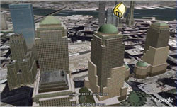
So what is a virtual world? A virtual world basically is an unreal world portrayed as if it were real. With the help of technology, virtual worlds are depicted as almost too real. Virtual worlds today include Google Earth, Nasa World Wind, and many other different softwares that portray the world as realistically as possible. Lets go further in depth into the virtual world of Google Earth Pro (the new edition). Google Earth Pro allows users to view a virtual earth as if it were realistic. You can zoom in on cities and see buildings in 3-dimensions. You can bascially look at any place on the planet in pretty good detail and get a good understanding of what's there, terrain and all. Google Earth even allows you to view the things you want to see. Just a click of the button can show you where national parks are or even where churches are. One of the cool things about the new Google Earth is the fact that you can place pictures of anything up for the world to see. This adds to the realism that Google Earth has to offer. Another one of the amazing things you can do is fly by's. These fly by's allow a user to mark a path any where within the virtual world and have the screen automatically jump there when you push play. This is cool if you want to show people a bike path you have been riding or the golf courses you've played. With all this new technology, there is some cons to using Google Earth Pro. While being a virtual world, it is not as realistic as you might want it to be. There are still many areas of the earth that are not as clear as others. Some of the terrain shown in 3-dimensional form is a bit rough as well. But who can complain. Software like this is very useful to many people professional or not. Software like this can enhance presentations greatly. You can not only show what an area looks like with a topo map or a picture, you can also add a view from space that shows fairly good detail and the physicla landscape. How can looking at urban growth of cities be any easier when you can actually see the buildings and residential areas. In conclusion, virtual worlds are amazing and can be greatly useful. The cons do not outway the pros and this software only gets better and better. The picture above is taken from the google earth website and shows the 3 dimensionality a virtual world can offer.
No comments:
Post a Comment