If you are an amateur map reader and your trying to learn about the topography of a certain area, understanding the map could come across as difficult. Without a good understanding of contour lines, elevation marks, and other symbols and features on a map, trying to get a good picture in your mind about the area you are about to explore is frustrating. After staring at this topographical map for just a few minutes, you probably wonder how much easier this map would be to use if it were three dimensional. It would be easier. Adding a 3rd dimension to the map not only makes the map look more exciting, but it also helps the viewer understand it easier.
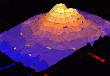
In most cases, looking at a map that is three dimensional gives the map reader a completely different perspective. This three dimensional view allows the reader to see the map in a way most people could not of imagined while looking at the map in a traditional fashion. For instance, try looking at a topographical map. You probably see the contour lines marking elevation. While everything looks flat on the map, these lines are detailing elevation and are a representation of what the terrain actually looks like. To the untrained eye, this map could be hard to read. Now looking at this same map in a three dimensional format, even a person who has never looked at a map before could tell the differences in elevation and get a good understanding of the terrain.
Three dimensional cartography not only benefits the viewer of the maps, but the cartographers as well. This extra dimension allows cartographers to show their information many more ways and gives the purpose of their maps a whole different perspective. For instance, if you were trying to make a map of downtown New York City and the purpose of this map was to show people the height of each building, a two dimensional map would seem bland and would probably not grab the attention of your viewers. However, a three dimensional map would jump out at your viewers and give them a good idea about the height of each building and a comparison to the other buildings.
In conclusion, three dimensional maps are fun and interesting to look at. They can give any traditional map a new purpose and allow readers to better understand that purpose.
The three dimensional map of a volcano above is taken from http://3dfmaps.com
No comments:
Post a Comment